Much has been written about the low standard of customer service in Bundaberg. But like any subject, there are exceptions. If any of my followers have experienced good service in Bundy, please add them to this blog by way of a comment.
Here is my list, so far -
No matter what time of day, whether it's raining or really hot, at the Neighbourhood Store in Elliott Heads Road Kepnock, I have always been welcomed with a smiling face and great service - well done to the owners and staff.
Justin at Bundaberg South Post Office always manages to greet customers with a smile, and remembers a lot of them by name.
The crew at the service desk at Kmart always seem to work well as a team to ease the queues at the other checkouts, and even when the queues are long, they always manage a smile.
Of all the sports stores in Bundaberg, the one with continual great customer service would have to be Avanti Plus in Bargara Road, East Bundaberg.
Bruce and his team at Hansens Auto Electrical are always happy to see you and the girls at the counter are always helpful.
I was ready in the newspaper today about someone having difficulty in getting good burgers and chips around Bundaberg area. Obviously they haven't been to the kiosk on the beachhead at Elliott Heads. Not only is the food great, but the staff are polite and courteous. I am always impressed by the way the younger staff address us oldies!!!
I needed to get my car serviced last week, preferably at home. I called Coral Coast Mobile Mechanic and was impressed with the thoroughness of the work - well done Michael.
Each time I go to Peter Walton Tyres, the staff and waiting room are always clean and tidy. The staff always great you with a smile. It seems to be the only place in Bundaberg to get a wheel alignment done correctly.
That's it from me for the moment - I'll add to the list when I remember or experience more great customer service.
Wednesday 28 December 2011
Sunday 25 December 2011
HMAS Aware - the final chapter
For many years, the former Attack Class patrol boat , “HMAS Aware” has been rusting away in the Burnett River between the Sugar Terminal and the Bundaberg Port Marina. Launched in Brisbane in 1967, the “HMAS Aware” was based at Darwin for a time, seeking Vietnamese refugee boats, and later transferred to Adelaide. It was decommissioned and sold to private ownership in the 1990′s. For sometime it was used as a dive boat and then arrived in Bundaberg in 2006. It had been an ugly sight – it was listing to one side and there had been some very unsympathetic additions above the deck (believed to have been added in Melbourne). At one point, it was advertised for sale for a mere AUD$85,000. See photo below, courtesy of http://www.boatsamillion.com/


In 2010, the surviving owner, a former crewman from the vessel, was fined $10,000 for failing to keep the vessel insured. This action has probably prompted the removal of the vessel from the river. Here are a couple of photos I took today of the 33m beauty as she lay awaiting the cutting torches.

What absolutely beautiful lines - the former "HMAS Aware" 22 Nov 2011 © JoWo12

The last resting place of the "HMAS Aware" 22 Nov 2011 © JoWo12
By crikey, I just got those first photos in the nick of time – have a look at this …………………
Put "Aware" in the search box for other posts about "HMAS Aware"
 |
| The stainless steel driveshafts beside the stern section ©2011 WoJo12 |
 |
| HMAS Aware - the following day |
Thursday 22 December 2011
Captured by Coonarr Charisma
One of the best walking beaches around Bundaberg is about 24km south at the most exclusive locality that is Coonarr Beach. I say exclusive as it is surrounded by nature reserves, and there are but 6 houses there and probably 6 vacant blocks of land. It physically cannot expand.
Walk to the beach and look in either direction - to the north in the distance one can see the township of Elliott Heads some 4km away, on the other side of the Elliott River. To the south, all one can see is 14 km of sandy beach, beyond firstly Coonarr Creek which is fordable at low tide. Then one can walk all the way to Theodolite Creek near Woodgate, after crossing One Mile Creek which is approx 12km from Coonarr Creek.
If you are contemplating walking here, take a large hat, sunblock and water - with our perfect unpolluted skies that sun can really burn, and there is little shade along the way.
- Nature's symmetry - 20 Nov 2011 ©2011 WoJo12

If you are contemplating walking here, take a large hat, sunblock and water - with our perfect unpolluted skies that sun can really burn, and there is little shade along the way.
Undaunted, I sauntered south into the wind,
Unthwarted by thongs or thrifty tourists,
I sallied through the shallows in the sand and shells and shingles.
The only souls around were the soles of my feet.
Twisted tossed trees trimmed the beach, stranded without soil or strength.
Eroded sandy cliffs remain after the scouring by the recent tides.
The sea eagle soars, searching for a single scrap of scaley seafood.
Small birds swiftly dart into the scrub on my approach.
Crabs speedily scamper for seclusion.
Shellfish draw delightful designs in the damp sand,
only to have them washed away in the waves of the incoming tide.
©2010 WoJo12
- That's it for this edition - I feel like going for a walk !!!!!!
 |
| Deep-rooted survivor under a Bundy sky - 20 Nov 2011 ©2011 WoJo12 |
Wednesday 21 December 2011
Mystery Object at Dr May's Point
When I walk north from Coonarr Beach towards the mouth of the Elliott River, It is amazing how nature periodically buries and unburies the relics from the past. Those of you following this blog will remember my post about the bus from Dr May's property.
About 440 metres south of that site, I had previously discovered a metal cylindrical object but lately it had completely been covered by sand. It is now uncovered again. It is about 1 metre long and probably 500mm in diameter. The end that is still intact is rounded, and it has been constructed using at least one row of rivets. It has a "shaft hole of about 80 or 90mm at each end, but they are offset by 90 degrees.
Can anyone offer any suggestions as to what it was????


In the same vicinity, another concrete trough has revealed itself. I have no idea what they were used for. Does anyone have any ideas???

Finally, on my return walk to Coonarr Beach, I found this poor turtle washed up on the beach.

Tuesday 20 December 2011
Kolan River Kayaking - #2
 |
| The former bridge section at Smiths Crossing ©2008 WoJo12 |
One of my favourite spots to launch on the Kolan River is at Smiths Crossing. A crossing at this point used to exist, but the local council have now totally removed the bridge section. The causeway on the southern approach remains and continues to make a great spot to launch.
From Smiths Crossing, one can paddle upstream for some 6km until a shallow section is reached. If you head downstream from Smith's Crossing, after about 3km you arrive at the bridge for Rosedale Road. Another 8 or 9 km will get you to Avondale Weir, where you see a great view of the steel bridge for the main north railway line.
 |
| Rail bridge at Avondale ©2008 WoJo12 |
Along the downstream section, there are lots of birds and animals to see. In a small backwater just downstream from Smith Crossing, I found this amazing sight. To the untrained eye, all these turtles appear to be the same, but several are not Kreffts Turtles - at least two are in fact the rare white-throated snapping turtle [Elseya albagula].
 |
| ©2008 WoJo12 |
More about kayaking the Kolan, in a later post.
Sunday 18 December 2011
Last Week in Bundaberg Port
On 13 Dec 2011 at the morning high tide, "Doris" left for Melbourne with a load of raw sugar, aided by the tug "Ballina". The tug "Wilga" returned to Brisbane a couple of days earlier. Our next sugar ship is not due until the middle of January 2012.
 |
| Last mooring line is gone, and "Doris" sails off to the Coral Sea - 13 Dec 2011 ©2011 WoJo12 The dredge "Everglade" came to Bundaberg from Port Douglas in April this year to restore the shipping channel following the floods. It appears that the dredge is now being prepared to leave Bundaberg following completion of the works. The spud poles have been removed and the cabin is sporting a new lick of paint |
 |
| The business end of the dredge "Everglade" earlier in the week ©2011 WoJo12 And now finally, in earlier post I related and illustrated the demise of the former navy patrol boat "HMAS Aware". Now there is nothing left at all. Here are a couple of photos of the last pieces being carried away. |
 |
| The rear section, showing the rudder mechanism ©2011 WoJo12 Below - the last piece of history, off to the scrap yard ©2011 WoJo12  |
Saturday 10 December 2011
Doris Graces Us With Her Presence
"Doris" arrived from Sydney yesterday. At this morning's high tide, the pilot steered the 182m vessel up the river aided by the tugs "Ballina" and "Wilga".
 |
In the Burnett River , from left to right - "Tharion", "Wilga", Doris and "Ballina 11 Dec 2011 ©2011 WoJo12 Now some of my blog followers may be asking about shipspotting in Bundaberg and how to find out the information of arriving and departing ships. My main source of ship schedules are various pages from the Port of Gladstone website. Remember that the Port of Bundaberg is under the control of the Port of Gladstone. So for the longer forecast, the shipping comapnies nominate approx when the ship might be due - up to 3 weeks in advance http://www.cqpa.com.au/webscripts/ShippingNotifications/ShippingNominations.asp?terminalid=92 Remember that there are two berths in Bundy and sometimes they sneak in a molasses ship at the other berth. Closer to the estimated arrival time, I check qships for finer information selecting the port of Bundaberg in the top right corner http://www.qships.transport.qld.gov.au/Public/PublicMovements.aspx Then 2 days out, I check the Duty Pilot Vessel Movements, looking for notations "BDB" or "sugar" - sometimes it is not obvious!!! http://www.cqpa.com.au/webscripts/Pilots/Schedule.ASP So there you have it - all you would be shipspotters, come on down and see it happen. The best viewing area is between the Bundaberg Port Marina and Wallace Creek - the ship channel is closest to the bank at that point. One last thing - to find out about a ship that is coming into port, or anywhere else in the world goto http://www.marinetraffic.com/ . Here is a link to the page on "Doris" http://marinetraffic2.aegean.gr/ais/shipdetails.aspx?MMSI=215080000 See you there.  |
Wednesday 7 December 2011
Road Safety in Bundaberg - Poor training, or couldn't care less
Whilst driving around Bundaberg in the rain yesterday, I again concluded what a useless, ignorant lot of drivers we have here.
It's drizzling rain, overcast skies and people are driving around in silver and other hard to see coloured cars with no lights on. They are almost invisible. Surely if you look down the road and say to yourself "Gee, that oncoming car is hard to see", you would immediately turn on your headlights (NOT your parklights which are intended to show where your car is when it is PARKED).
Then we have the drivers, not knowing or not caring about any other drivers on the road, who at the last minute indicate to turn. IF YOU HAVE PUT YOUR FOOT ON THE BRAKE PEDAL, YOU SHOULD HAVE ALREADY INDICATED. I'm not sure how some people got their licences.
The next bunch of drivers we have to contend with are those who were brought up driving old cars with really heavy steering. Now driving modern cars with light and/or power assisted steering, they still swing to the right to turn left, or swing to the left to turn right. A lot of these people just should not be driving if they do not have the ability to negotiate an intersection without endangering other drivers.
This situation is not helped by our local council who persist with continuous white lines right up to the point of the intersection. Most Bundaberg drivers do not use these as a guide as they are normally positioned on the road right beside the centre line, as they have no idea how wide their vehicle is, or where that lefthand white line is.
Now saying all this is fine, but unfortunately there is no way currently of enlightening these ill-educated or un-educated drivers. The problem is that not only are they endangering the lives of themselves and their passengers, often small children, but they unknowingly could cause a following car to run off the road or hit another car, while they drive on in ignorance of the carnage they have caused.
If you agree with me, please write a comment. If you disagree, tell me also.
WoJo12
Tuesday 6 December 2011
Happenings at The Bundy Port 06 Dec 2011
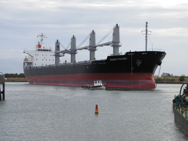
While waiting for the re-scheduled departure of the "Ocean Victory" today, I decided to have a look at the conditions in the open sea. It was very windy with quite a swell running.
But the best part of the detour occurred when I spotted a loggerhead turtle coming ashore at Oaks Beach at Burnett Heads. She struggled for a metre or so, then rested, and repeated this routine many times.
With a group of people watching from a distance, she eventually got to the wooden steps up to the road. After nearly getting stuck under the railing, she gave up and returned to the sea. Hopefully she'll be back later tonight.
But the best part of the detour occurred when I spotted a loggerhead turtle coming ashore at Oaks Beach at Burnett Heads. She struggled for a metre or so, then rested, and repeated this routine many times.
- Turtle coming ashore at Oaks Beach (Burnett Heads) 06 Dec 2011 ©2011 WoJo12
 |
 |
| Almost stuck at the steps, Oaks Beach 06 Dec 2011 ©2011 WoJo12 |
Now, back to the original reason for this post. Laden with sugar and consequently much lower in the water, the "Ocean Victory" left the Port of Bundaberg, assisted by the tug "Ballina" late this afternoon.
- "Ocean Victory" sailing down the Burnett River 06 Dec 2011 ©2011 WoJo12
 |
Monday 5 December 2011
ADDICTED TO WREX (THE SUBARU RALLY EXPERIENCE)
 |
| Car - by WRX Drift Experience, Driver - WoJo12 (Photo ©2011 WoJo12) |
Last month, I had one of the best days of my life - having recently had a successful month in my small business, I decided to shout my son and myself a rally car experience at the Gold Coast, after all, it is nearly Christmas. After an almost 5 hour drive we arrived at the track at Pimpana to be joined by about 8 or 9 other participants. The cars were 350 horse-power Subaru WRX STi's and our package was 2 lots of 5 laps, with an instructor beside us telling us about the correct lines, when to brake and when to floor it (the best part - the noise was fantastic under full power).
It was a hot day and the cars are not air-conditioned (saps too much power, I guess) and I was sweating like a pig!!!! After 5 laps, you just start getting into the swing of things, get most corners correct, and are more comfortable in the unfamiliar surroundings. But then you must stop to give the others a go.
After we had all completed our laps, my son and I were called into the training room. I thought "what have we done". There were very strict rules laid out at the initial drivers briefing, and warnings of severe and costly consequences if a driver, for example, hit the tyres on the edge of the track or did not obey the instructor's directions. But soon I was relieved to find that they were making a presentation - my son had recorded second fastest time of the day .... I was presented with a trophy for fastest time of the day. Neither my son nor I had ever driven an all-wheel-drive car before. I was so excited that I wanted to do another session while we were there, but time and money prevented that. If anybody ever has the slightest chance to do something like this, grab it with both hands - you'll never ever regret it. Many thanks to my instructor, Jess, for her patience and perseverance with me. http://www.wrxdrift.com.au/
Well that's it from me, for my first post - see you here next time.
FISHING FOR THE FACTS
 |
| Kayak fishing at the mouth of the Kolan River ©2008 Wojo12 |
Now let me say from the outset that I am not a fisherman, I am not a “greenie” nor am I an anti-cruelty activist. From my perspective, it seems that there are basically three type of fishing – fishing for food for personal consumption, fishing for fish for sale both as they are, or processed, and then there’s the so-called “sport-fishing”.
Now for the sake of the debate, let’s assume that the birds of the air were wonderful to eat. Can you picture a man in his backyard or in the bush somewhere, with a rod and reel with a hook and a worm, trying to capture a particular species for dinner. His first catch for the day happened to be a sparrow, hardly a good size for one man. He rips the hook out of the poor bird’s mouth and encourages it to fly away.
He baits his hook again and dangles it in the breeze, awaiting a larger species. This time he reels in a honey-eater, which as you can imagine, put up a bigger fight than the sparrow. The man says to himself “caught one of those last week, didn’t taste too good” and again removes the hook from the stricken bird and sets it free, not knowing or caring if it survives.
Undaunted, the man goes to the beach- “seagulls are biting this time of year, and they taste better as well” he says as he loads his hook with a tasty morsel. This time success, after 3 attempts he finally catches his lunch.
If this were really happening - can you imagine the outcry from the RSPCA, Greenpeace and Earth-Watch, from Bob Brown, the CWA and the Animal Liberation groups? I have no qualms about anyone fishing for food, but can we continue to allow sport fishing where marlin angling is the equivalent of the now-outlawed foxhunt. The stress to the marlin or any other fish is unknown, the damage to the health of the fish is not known, but we continue to allow this cruel “sport”. Does anyone have any research on the survival of big game fish after being hooked, hauled aboard, and severely stressed and then being thrown back into the water and forgotten?
That’s it for me – let me have your views by writing a comment below.
Sunday 4 December 2011
Ocean Victory Stranded In Bundaberg
Well, my post about the sugar ship "Ocean Victory" yesterday has proven to be not accurate, but not my doing. The ship is all loaded up and ready to go, but, alas, there is no pilot available to take the ship back out to sea.
Because of the infrequent visits of ships to our port, the pilot who navigates the ship into the river and to the sugar terminal drives down from Gladstone for the occasion. The Port of Bundaberg is controlled by the Gladstone Ports Corporation. The Harbour-Master for the Port of Bundaberg is also in Gladstone.
So we have the "Ocean Victory" in port until the scheduled departure on 7 Dec 2011, weather permitting.
In the meantime, here is another photo of the ship, swinging off the port anchor.
Saturday 3 December 2011
Ocean Victory for Bundaberg
Well, after the strong winds in the Wide Bay have subsided sufficiently, today finally saw the arrival in port of the "Ocean Victory" from Yokohama. Scheduled originally to dock on Friday's daylight high tide, the 169m ship was escorted up the Burnett River by the Tug "Wilga" from Brisbane, and locally-based tug "Ballina".


 |
| Tug "Wilga" at the entrance to the Burnett River 04 Dec2011 ©2011 WoJo12 |
Well, after the strong winds in the Wide Bay have subsided sufficiently, today finally saw the arrival in port of the "Ocean Victory" from Yokohama. Scheduled originally to dock on Friday's daylight high tide, the 169m ship was escorted up the Burnett River by the Tug "Wilga" from Brisbane, and locally-based tug "Ballina".

The "Ocean Victory" entering the Burnett River 04 Dec 2011 ©2011 WoJo12
The most technical part of the docking is turning the ship around in the confines of the river. At the swing basin, the ship dropped its port anchor, and then the tugs began the job of swinging the ship about the anchor.

The "Ocean Victory" almost about, while the line boat awaits the mooring lines 04 Dec 2011 ©2011 WOJO12
The final step is to ease the vessel to the Bulk Sugar Terminal, gently pushed by the assisting tugs.

Tug "Ballina" pushing the "Ocean Victory" to the dock, pilot vessel "Kareela" already tied up 04 Dec 2011 ©2011 WoJo12
If everything goes according to plan, loading should be finished in time for the ship to leave on tomorrow's daylight high tide.
Wednesday 30 November 2011
About Dr May's Island
At the mouth of the Elliott River lies Dr May's Island (sometimes erroneously referred to as “Rock Island”). Once part of the mainland, it was the site of the May's house and farm. One part of the property was an old bus which was used for casual accommodation for their visitors.
In the fifties, the land joining the “island” to the mainland started to get washed away. This was accelerated by some fishermen carving a channel for them to get access to some fishing spot or other. Then cyclonic seas and stormy weather eventually saw the island become permanently separated and the bus and other farm infrastructure became victims to the sandy seas.
Recently, while walking on the beach, south of the Elliott Heads river mouth, I discovered that nature had given us back that bus - the chassis and tyres are clearly visible above the receding sands. Some 400m further south, the chassis of a smaller motor vehicle can also be found. In this area are several large pieces of concrete and steel - identity as yet unknown.
- I had walked the 3km to the site now only accessible by this walk or by boat. But unfortunately time and tide didn't wait for this man - I should have checked before I left home. Still it was a beautiful afternoon, the herds of hordes had left, leaving the beach to me and my lengthening shadows from the setting sun. The real bus photos will have to wait for another day, however here is a phone camera of the site with Dr May's Island in the background.
-
 |
Dr May's Island in the background, from the southern head of the Elliott River - 19th Nov 2011 ©2011 WoJo12 |
-
 |
| Rusting vehicle chassis on Coonarr Beach - 20/11/2011 ©2011 WoJo12 |
Here is another piece of Dr May's Island history, barely above the sands of Coonarr Beach. I only took one photo of the concrete pit which has been totalled exposed in the past, but currently it is all but buried.
-
- Concrete pit semi-submerged under the sands of Coonarr Beach - 20 Nov 2011 ©2011WoJo12
 |
Earlier, I have referred to my discovery of various objects currently emerging out of the sand at Dr May's Point. Well, now the low tide has been at a better time to again walk the 6km round trip from Coonarr Beach.
With an easterly wind blowing, it was amazing what was on the normally quite clean beach - among the leaves littering the shoreline, were quite a few jellyfish, commonly known as bluebottles (or Portuguese man-o'-war, Pacific man-o'-war). This species is a partially beautiful blue, but that is where the beauty finishes - contact with them can be quite dangerous. Just for variety, there were also half a dozen or so dead fish, believed to have been rejects from a trawler operating off the coast this week.
As I arrived at Dr May's Point, I could see that this time I had timed the tides correctly and the bus chassis was clearly visible. I removed various sticks that had been caught in the wreck. I did not attempt to move the 100mm diameter steel pipe lying diagonally across the chassis. The front tyre as well as the two rear tyres are now quite visible.

- The bus chassis at low tide - 25 Nov 2011

- Believed to be the upside-down steps from Dr May's house - 25 Nov 2011

- A very vertical post, possibly stump from Dr May's home - 25 Nov 2011

- Another concrete relic in the sands - 25 Nov 2011
One last note - for more on Coonarr Beach, look for a another post
Monday 28 November 2011
Bundaberg's Hidden Gem
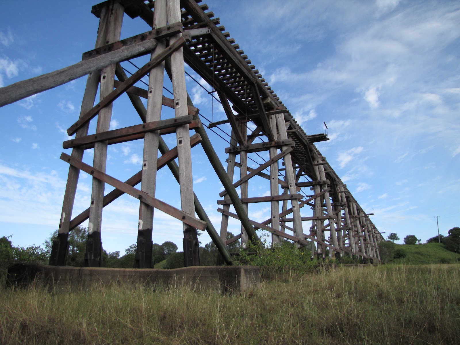
Unbeknown to a lot of Bundabergians and to our visitors, our most awesome bridge lies less than 7km west (if you are a crow) from the Bundaberg Post Office. Formerly part of the Bundaberg to Mount Perry railway line, this bridge over Splitters Creek is now landlocked by private land and can only be accessed by negotiation by the land owner. I had originally thought I may be able to kayak up Splitters Creek to the bridge. But because of the meandering nature of the creek, the tides and the fact that the nearest launch-point I could find was beneath the Traffic Bridge, it was going to be marginal whether I could get to the bridge before the tide receded and left me high and dry.
So don't tell anyone about it - you must keep a secret less the Bundaberg Regional Council find out about its existence, its tourist value and the fact that it is an important part of Queensland's history.


All photographs taken on 26th April 2010. ©2010 WoJo12
This bridge is believed to be the longest and highest wooden trestle bridge surviving in Queensland.
Many thanks to Greg M for organising the visit with the landowner.
Kolan River Kayaking - #1
I was introduced to kayaking by a friend in 2008. Since then I have paddled most of the lower reaches of the Kolan River, just north of Bundaberg. From its entrance to the Coral Sea to the weir at Bucca, the river scenery varies from the estuarine mangroves near its mouth to the pebbled beaches, to the tunnels of trees in its upper reaches.
There are several launch-points along the river - my first cruise began from Bucca Crossing, a lovely picnic spot and it has good access to the water. From here one can paddle easily upstream in normal conditions.
I waited for another half an hour or so, and soon the single sunning turtle was joined by another, and by another - it was hypnotic - my eyes were constantly scanning the river for others - it really was alive.
There are several launch-points along the river - my first cruise began from Bucca Crossing, a lovely picnic spot and it has good access to the water. From here one can paddle easily upstream in normal conditions.
- I thought this is very beautiful and serene. But then I stopped for a longer break, hanging on to an overhanging tree - there IS a current in this river after all!!! After a few moments the air became alive with different sounds - the river itself was silent but its residents were not. Various birds were singing, and then out of the corner of my eye I heard a splash and just managed to see a turtle ducking for cover into the waters. I waited and I waited, camera at the ready. Then I had a good look at my first Kolan turtle, as it clambered back onto its precarious position on a sunny log.
 |
| Upstream from Bucca Crossing 29th June 2008 ©2008 WoJo12 |
 |
| Krefft's (River) Turtle - Chelymys krefftii 17 Jul 2008 ©2008 WoJo12 |
More kayaking and uncovering the inhabitants of the Kolan in later posts.
Pemberton - the railway terminus
One of the last remnants of the Bundaberg-Qunaba-Bargara (then Sandhills) -Pemberton railway line is up for sale. In the early 1900's, a railway line, or tramway, was built from Bundaberg to Sandhills, then inland again to finish at Pemberton. Where is Pemberton you may ask - read on!!!!
After sweeping around the southern boundary of the Club, the track finished beside Elliott Heads Road. At the terminus, a triangle was constructed which enabled trains to turn around to proceed back from whence they came ( a modern example of such a triangle can be seen in Hoods Road, near the main North Line). This section of the railway was last used in 1948.
A few years ago the land that was a part of the railway terminus was subdivided into 5 acre blocks. Now one of those blocks contains the remains of the Pemberton Grange Sugar Mill, and another borders the curve of the triangle.
Now is your chance to own a bit of history!!!!!
Now - back to the subject. Believe it or not, the railway came from the vicinity of Seaview Road/Windemere Road intersection and headed south, crossing Innes Park Road at the eastern boundary of the now Innes Park Country Club. The remains of the permanent way to the north of Innes Park Road was until recently quite visible, but now a farmer has salvaged the gravel and it is a lot lower than it used to be. The rockwork on the southern side of Innes Park Road is still visible, and when the grass is greener, the distinct curve of the permanent way is quite clear.
 |
| From Innes Park Road, looking north, showing the old permanent way 27 Nov 2011 ©2011 WoJo12 |
 |
| The curve of the old triangle is easy to see 27 Nov 2011 ©2011 WoJo12 |
 |
| [Map Overlay ©2011 WoJo12] |
A few years ago the land that was a part of the railway terminus was subdivided into 5 acre blocks. Now one of those blocks contains the remains of the Pemberton Grange Sugar Mill, and another borders the curve of the triangle.
 |
| Pemberton Grange Sugar Mill 1898 [John Oxley Library, State Library of Queensland Neg: 12345] |
 |
| Pemberton Grange Sugar Mill 27 Nov 2011 ©2011WoJo12 |
Subscribe to:
Posts (Atom)